













By Enyichukwu Enemanna
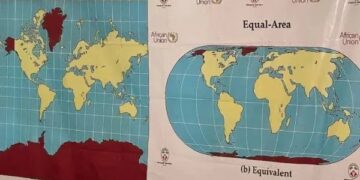
The United Nations General Assembly on Friday approved an African-led resolution seeking to correct the distortion of Africa’s size on world maps, a resolution that aims to counter perceptions that the continent is peripheral.
A total of 164 countries voted in favour of the resolution, while the United States was the only country to vote against it.
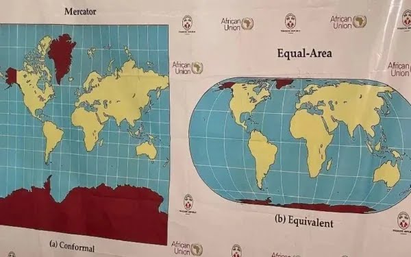
Championing the resolution on behalf of the African Union, Togo is urging governments, schools and technology companies to adopt equal-area map projections, such as the “Equal Earth” projection, instead of the centuries-old Mercator projection, which has long made Africa appear smaller than its true size.
First developed in 1569 for nautical navigation, the Mercator projection significantly enlarges landmasses located farther from the equator.
Because Africa straddles the equator, the projection makes the continent appear considerably smaller relative to Europe, North America and Russia.
Togolese Foreign Minister Robert Dussey described the move as a “scientific” rather than “political” correction. “We just want to have the real size that we have in the world in terms of geography,” Dussey said ahead of the vote.
It is not legally binding and it “in no way challenges the use of the Mercator projection for maritime and aerial navigation, for which it remains fully suited,” the Togolese ministry said in a statement.
Mercator projection remains useful for navigation and is not banned. Instead, it promotes equal-area maps as the preferred global standard for educational and institutional use.
The Togolese foreign ministry also urges the 193-member UN body to recognise that “maps have a significant impact on how people perceive the world.”
The vote marks a diplomatic victory for the African Union, which has for years sought to challenge the visual distortion of the continent and ensure that Africa is represented more accurately on maps.
The United States, the only country to vote against the resolution, said it promoted an “ideological agenda” and was a distraction from the “genuine problems of international peace, prosperity or good relations”.
Togo plans to meet African Union member states and supporters from other regions within the next six months to agree on how to promote wider adoption, Dussey said.
Dussey said the discussion about next steps would need to include companies operating mapping, GPS and other location-based technologies.
Dussey linked the campaign to adopt the map to wider African efforts to confront colonial-era legacies, while saying it was not an attack on Europe or any other civilisation.